Lafferty
Ranch Historical Map Close-ups
|
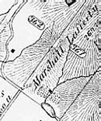
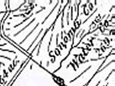
At right is a close-up of the 1877 historical map focusing on the corner of Lafferty Ranch that touches Sonoma Mountain Road. Note the western corner of the property. An entrance driveway is shown (near the "M" in Marshall Lafferty) from Sonoma Mountain Road which appears to be completely clear of the adjacent properties. That western corner of the Lafferty property seems to correspond to the inside (western) corner of the right-angle bend in Sonoma Mountain Road. That would mean the entire road right-of-way would be inside the Lafferty property. This alignment is shown even more clearly in the 1898 map, below, where the former Lafferty property is shown belonging to the "Sonoma Co. Water Co." That these two factors -- road right-of-way within the Lafferty property and the driveway into that property shown clear of adjacent parcels -- is significant. We believe is shows conclusively that people who drew up the original property lines (which remain the same today), road right-of-way, and official maps had no doubt about the Lafferty property's clear access to Sonoma Mountain Road. This may explain why neighboring landowners have never been able to produce documentation of any easement granted across their properties for access to Lafferty. It would have seemed obvious to the early landowners that no such easement was required, since the Lafferty property had clear access to the road. Currently, the road pavement is around twenty feet away from the Lafferty fencelines, which has led the neighbors to the north and south of the Lafferty gate to claim they control access from the road to Petaluma's Lafferty Ranch property. How did this situation arise? Rural fencelines are notoriously fluid and imprecise, so it is likely they have wandered over time. But we think the main culprit is the sharp, 90-degree, left turn in Sonoma Mountain Road (which, ironically, was put there to follow property lines and give explicit road access to Lafferty Ranch). We believe road paving crews -- and prior to its being paved, road users -- have incrementally "cut", or rounded that corner to make it safer and more direct. In so doing, they have gradually moved the road away from the Lafferty Ranch property. It is also worth noting that Petaluma commissioned a boundary survey in 1998 which substantially agrees with these historical maps. See also these photographs of the Lafferty gate area today. |
Close up of 1877 map:
Close up of 1898 map (below):
|
![]()